

Super Interactive Maps
/Year
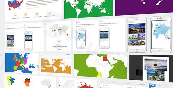
In today’s visually driven digital landscape, presenting geographical information effectively can significantly enhance user engagement and clarify complex data. The Super Interactive Maps WordPress Plugin is a comprehensive, premium solution meticulously engineered to empower website owners, marketers, and content creators to design and deploy stunning, interactive maps with unparalleled ease. Integrating seamlessly with the Google Geochart API and leveraging advanced Google Maps API functionalities, this plugin transforms static geographical data into a dynamic, user-friendly experience on your WordPress site.
Why Choose Super Interactive Maps? Expertise and Reliability for Your Website
Choosing the right tools for your WordPress site is crucial for performance, security, and user experience. Super Interactive Maps stands out as a premium offering, designed with both power and simplicity in mind. For those acquiring this plugin from trusted sources like ZeroPlugin.com, you are investing in a secure, legitimate, and continuously updated asset for your digital presence. Distributed under the GPL license, all files are rigorously scanned for security, ensuring a safe deployment on your website. Furthermore, consistent updates guarantee compatibility with the latest WordPress versions, providing peace of mind and sustained functionality. This commitment to security, compatibility, and ongoing support underscores the plugin’s inherent trustworthiness and expert development.
Unlocking Powerful Features: Key Capabilities of Super Interactive Maps
Super Interactive Maps is packed with an array of features designed to cater to diverse mapping needs, from simple location displays to intricate geographical data visualizations.
- Extensive Map Library & Advanced Regional Breakdown: Gain access to an unparalleled collection of over 300 detailed vector and SVG maps. This includes all 195 countries worldwide, major continents (Africa, Europe, Asia, Oceania, the Americas), and specialized maps for key nations such as the USA, UK, Canada, Australia, India, China, Germany, and France, often complete with regional and state-level breakdowns for granular detail.
- Seamless Google Geochart & Google Maps API Integration: At its core, the plugin leverages the robust Google Geochart API for rendering beautiful, data-driven maps. For precise location management and interactive markers, it integrates directly with the Google Maps API, ensuring accuracy and performance.
- Intuitive Location Management with Autocomplete Search: Effortlessly pinpoint and add locations to your maps using a smart autocomplete search feature. Combined with a drag-and-drop marker system, powered by Google Maps API, placing points of interest like hotels, restaurants, airports, or event venues becomes an intuitive and efficient process.
- Full Customization for Tailored Aesthetics: Take complete control over your map’s appearance. Customize styles, colors, and choose from various display options including showing regions, markers, or text labels. This flexibility ensures your maps perfectly align with your website’s branding and aesthetic.
- Rich Interactivity with Tooltips and Lightbox Popups: Elevate user engagement through dynamic interactive elements. Incorporate responsive tooltips that appear on hover, and lightbox popups capable of displaying rich content such such as text, images, and videos. This allows you to present detailed information directly on the map.
- Link Regions and Markers to URLs: Extend interactivity by linking specific map regions or custom markers to external URLs or internal pages. This feature is invaluable for guiding users to relevant content, product pages, or detailed information about a geographical area.
- Dynamic Zoom and Pan Functionality: Enhance the user experience with interactive zoom and pan capabilities. This allows visitors to explore specific areas of your maps in detail, making complex geographical information easy to navigate and understand.
- Option to Hide Other Regions: Focus user attention precisely where you want it. This feature allows you to selectively hide or de-emphasize surrounding regions, highlighting the areas most relevant to your content.
- Universal Compatibility & Responsive Design: Crafted with modern web standards, Super Interactive Maps is fully responsive, ensuring your maps look and function flawlessly across all devices—desktops, tablets, and smartphones—and major web browsers. It also boasts compatibility with popular WordPress page builders, including Visual Composer, for seamless integration into your design workflow.
- Easy Implementation with Shortcodes: Deploy your custom-designed maps anywhere on your WordPress site with remarkable ease. Simple shortcodes can be placed within posts, pages, or sidebar widgets, allowing for flexible and quick integration without any coding knowledge.
- Lightweight Architecture: The plugin is designed to be lightweight, ensuring that your interactive maps do not negatively impact your website’s loading speed or overall performance.
Ideal Use Cases for Enhanced User Experience
The versatility of Super Interactive Maps makes it an indispensable tool for a wide array of websites:
- Business Directories: Visualize branch locations, service areas, or client geographical data.
- Travel Blogs & Agencies: Showcase destinations, tour routes, or points of interest with interactive guides.
- Real Estate Listings: Display property locations, neighborhood information, or regional market trends.
- Event Location Guides: Pinpoint venues, parking, and related amenities for events.
- Educational Sites: Illustrate historical movements, geographical concepts, or demographic data.
- Journalism & Data Visualization: Present complex geographical statistics in an accessible, engaging format.
Setup and Implementation: A Straightforward Process
Setting up Super Interactive Maps is designed to be user-friendly, catering to both technical and non-technical users.
- Installation: Like any premium WordPress plugin, you’ll upload the plugin file via your WordPress dashboard (
Plugins > Add New > Upload Plugin) and activate it. - Configuration: Navigate to the plugin’s settings within your WordPress admin area. Here, you’ll typically configure your Google Maps API key (if required for certain features) and general map display options.
- Map Creation: Utilize the intuitive interface to create new maps. Select your desired map type (country, continent, region), add custom markers using the autocomplete search and drag-and-drop functionality, and define interactive elements like tooltips and popups.
- Customization: Personalize the map’s appearance with colors, styles, and display options to match your website’s design.
- Deployment: Once your map is designed, the plugin generates a unique shortcode. Simply copy and paste this shortcode into any post, page, or sidebar widget where you wish your interactive map to appear.The plugin is lauded for its comprehensive documentation, which serves as an excellent resource to guide users through every step of the setup and customization process.
Conclusion: Elevate Your Geographical Content with Super Interactive Maps
Super Interactive Maps is more than just a plugin; it’s a powerful content enhancement tool that brings geographical data to life on your WordPress website. Its robust feature set, intuitive design, and commitment to compatibility and security make it a prime choice for anyone looking to create engaging, informative, and visually appealing maps. By providing accurate, detailed information through a user-friendly interface, this premium solution establishes itself as an authoritative and trustworthy asset for businesses, content creators, and educators alike.Elevate your website’s functionality and visual appeal today. Invest in Super Interactive Maps to transform how your audience interacts with geographical information, ensuring a dynamic and enriching user experience for years to come.
I. Download Limits & Account Benefits
- Free Downloads: Each email address receives 3 downloads per day for free products
- Upgrade Benefits: Purchase any paid product to increase your daily download limit by 3 for each paid product
- No Account Required: You can download immediately by receiving the download link via email
- Account Recommended: Create an account for easier access to your order history and direct update downloads
II. Understanding GPL vs Official Versions
Important: The products available on WPPick are GPL-licensed versions, which differ from official developer versions. Before purchasing, please read our comprehensive guide: Understanding GPL & Official Differences at WPPick
Key Points:
- GPL versions may not include premium support from original developers
- Updates may be delayed compared to official releases
- Some premium features might have limitations
- Always consider your specific needs and support requirements
III. Support & Assistance
We’re here to help through multiple channels:
- Email Support: Direct email assistance for all inquiries
- Live Chat: Real-time support during business hours
- Comprehensive Documentation: Detailed guides and tutorials
IV. Order Tracking
Access your complete purchase history and download links anytime: Order History
V. Account Access
New to WPPick? Login or Create Account to manage your downloads and orders efficiently.
VI. Refund Protection
We stand behind our products with a clear refund policy. Review our terms: Refund Policy
VII. Privacy & Security
Your data security is our priority. Learn how we protect your information: Privacy Policy
VII. Terms of Service
Understanding our service terms ensures a smooth experience: Terms of Use
Quick Tips for Best Experience
- Verify Compatibility: Check plugin/theme compatibility with your WordPress version
- Backup First: Always backup your site before installing new plugins or themes
- Test Environment: Consider testing on a staging site first
- Stay Updated: Regularly check for updates in your account dashboard
- Read Documentation: Review any included documentation for optimal setup
Need Help?
If you have questions about downloads, licensing, or need technical assistance, don’t hesitate to contact our support team. We’re committed to ensuring you have the best possible experience with WPPick products.
Ready to get started? Your download adventure begins with just one click!
- Sanitize admin parameters